

On the Evolution of the Middle East
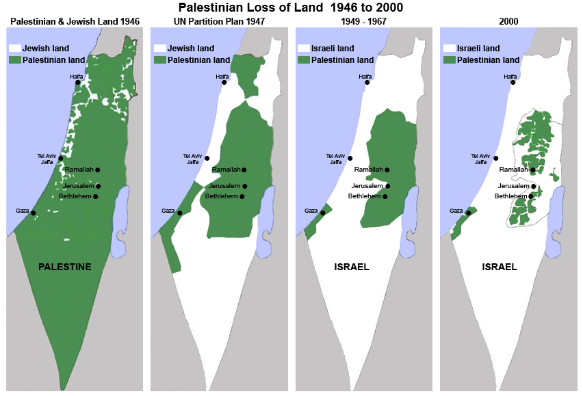
Perhaps you have seen this map before. You can find it all over the internet. It claims to illustrate the "Palestinian loss of land" from 1946 to 2000. In the words of the Friends of Sabeel, a Palestinian Christian organization, the map "succinctly illustrates Israel's expansion and West Bank settlement policies since 1948." According to other websites, it exposes the "strategy of a greater Israel" at the expense of Palestine.
The problem is that this map has little to do with reality, for it completely misrepresents the recent history of Palestine-Israel.
The map's deceptiveness was already exposed several times on various blogs and websites (Dvar Dea).
The following video explains well how the maps "rewrite history by shifting definitions, mislabeling entire regions, and using visual tricks to push a false narrative."
Nevertheless, old lies die hard, and so we present here our own summary of the evolution of the map of the Middle East.
Map 1 (1946): No State of Palestine but the British Mandate
") The first map (labeled "Palestinian and Jewish land 1946") shows "Palestinian land" in green comprising more than 90% of "Palestine," suggesting that, in 1946, nearly all the land between the Jordan and the Mediterranean was "Palestinian." Land designated as "Jewish" in this map constitutes maybe five percent of the total. This map is ridiculous, not only because the term "Palestinian" in 1946 referred, generally speaking, to the Jews who lived in Palestine, not the Arabs, but because there was no Palestinian state in 1946 (nor was there an Israeli state.) There was only the British Mandate of Palestine, in which both Jews and Arabs lived. Jews lived throughout the territory then occupied by the British, including on land that today constitutes the West Bank.
The first map (labeled "Palestinian and Jewish land 1946") shows "Palestinian land" in green comprising more than 90% of "Palestine," suggesting that, in 1946, nearly all the land between the Jordan and the Mediterranean was "Palestinian." Land designated as "Jewish" in this map constitutes maybe five percent of the total. This map is ridiculous, not only because the term "Palestinian" in 1946 referred, generally speaking, to the Jews who lived in Palestine, not the Arabs, but because there was no Palestinian state in 1946 (nor was there an Israeli state.) There was only the British Mandate of Palestine, in which both Jews and Arabs lived. Jews lived throughout the territory then occupied by the British, including on land that today constitutes the West Bank.
Most of this land was neither owned by Jews nor Arabs, but was under the political control of the British Empire and largely vacant - especially the bottom half of the map, which was mostly unpopulated desert.
The intent of this propaganda map is to suggest that an Arab country called "Palestine" existed in 1946 and was driven from existence by Jewish imperialists. In reality, most of this "Palestinian" land was "Palestinian" only in the sense that it was public land owned by the British mandatory government of Palestine.
Not only was there no Palestinian state in 1946; there has never been a country called Palestine. Before the British conquered Jerusalem, Palestine was a sub-province of the Ottoman Empire. After the British left, Jordan and Egypt moved in to occupy Gaza and the West Bank, respectively.
Map 2 (1947): The U.N. Partition Plan - Never Came into Existence
") The second map is a rendering of the U.N. Partition Plan, which would have divided the British mandate into two equal parts, one part for Arabs and one part for Jews. It appears to show a massive loss of "Palestinian land", but in fact it reflects the fact that the largely vacant and inarable Negev desert was partitioned by the U.N. to Israel.
The second map is a rendering of the U.N. Partition Plan, which would have divided the British mandate into two equal parts, one part for Arabs and one part for Jews. It appears to show a massive loss of "Palestinian land", but in fact it reflects the fact that the largely vacant and inarable Negev desert was partitioned by the U.N. to Israel.
The Jews accepted this partition of Palestine, and the Arabs rejected it. When Israel declared independence, the Arabs sought to eliminate the U.N.-supported Jewish state, but they failed.
So this map was only a theoretical solution proposed by the U.N. but it never came into existence on the ground because of the refusal of the Arabs to accept the existence of a Jewish State in what was formerly the British Mandate of Palestine.
Map 3 (1949-67): Jordanian West Bank, Egyptian Gaza
") The third map shows further decline in "Palestinian land" which resulted from Arab losses in the 1948 war. The map fails to mention that this was a war of aggression started by the Arab states, thereby absolving them of responsibility for those losses.
The third map shows further decline in "Palestinian land" which resulted from Arab losses in the 1948 war. The map fails to mention that this was a war of aggression started by the Arab states, thereby absolving them of responsibility for those losses.
The map also falsely describes the Gaza Strip and the West Bank (including East Jerusalem) as "Palestinian land." In fact, Jordan annexed and occupied the entire West Bank, and Egypt occupied Gaza.
The map also omits the fact that Arabs owned (and still own) private property in those white areas - in Israel, as does the Muslim Waqf and the Greek Orthodox Church.
Map 4 (2000): Omitting the Key Facts
") The last map (labeled "2000") is especially deceptive because it omits an impressive list of key facts:
The last map (labeled "2000") is especially deceptive because it omits an impressive list of key facts:
- It is silent about several other wars launched against Israel by its Arab neighbors, most notably the 1967 Six-Day War (Egypt, Jordan, Syria) and the 1973 Yom Kippur War (Egypt, Syria).
- It omits the Israeli withdrawal from the territories gained in these wars, especially the entire Sinai peninsula.
- It omits the fact that it was Israel who gave land to the Palestinians, and not Egypt or Jordan who ruled the Gaza Strip and the West Bank prior to 1967.
- It omits the facts that Israel offered more land to the Palestinians in exchange for peace in 2000; but the Palestinian leadership rejected this offer.
- It omits the murderous violence that Palestinians launched against Israeli citizens after that rejection, during the Second Intifada.
- It omits the 2005 disengagement from Gaza, when Israel surrendered the entire Gaza Strip to Palestinian control, and the subsequent rise of the Islamic terrorist organization Hamas there.
- It omits the constant Palestinian Qassam rockets attacks on Israeli population centers in the south of Israel, Israeli Prime Minister Olmert’s offer to PA President Abbas in 2008 to give more land to the Palestinians, and Abbas' rejection of that offer.
In closing, we would like to propose a more accurate map (produced by StandWithUs) for those interested in a more objective view of the evolution of the Middle East (or click below to download the full-sized pdf map):

